Saturday, August 17, 2013

Influences

I’ve had a tough time in Yellowstone and Grand Teton and fallen into a bit of a slump. I stayed in bed late with a sore side that may be a pulled muscle from climbing Inyan Kara or may just be the bed. I feel too tired to hike any big trails so I explore the hydrothermal features in the west side of the park. All of these are mere feet from the parking areas and I’m frustrated by the fact that any interesting angle from which to photograph these features will inevitably include the parking lot full of cars in the background or the boardwalk trail that was built to lead to the spring. This encourages me to try some different compositions to avoid the clutter but I’m just not excited about the results.
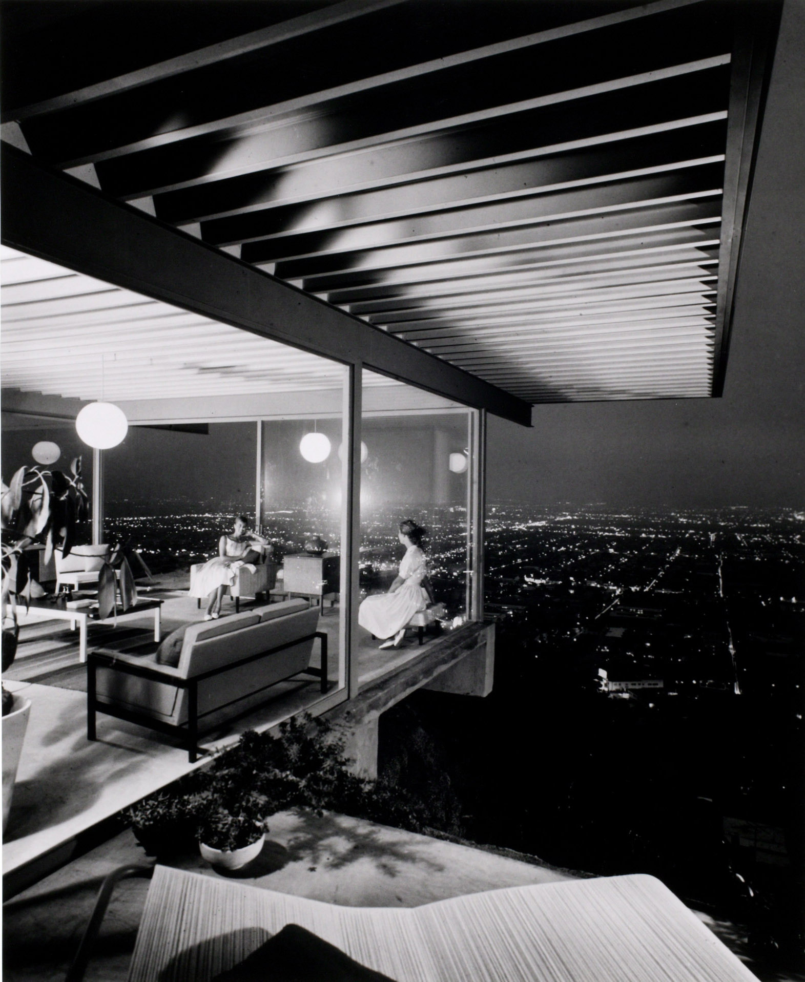
I think that my frustration is not Yellowstone’s fault; this is a gorgeous landscape; but my own for not figuring out a way to depict it in photographs. This may be a good time to describe the visual style that I strive for. I’m inspired by photographers that look for patterns and organization in a chaotic scene. As such I’m a fan of architectural photographers; JuliusSchulman in particular. Schulman popularized modernism by making the houses he photographed look to be better designed than they often were. He did this by using single point perspective and by drawing the viewer’s attention to interesting features using light and dark. I also really like the work of Andreas Gursky. Gursky finds organization in chaotic scenes like a factory floor, a racetrack or a supermarket aisle. 
I try to discover the geometry of a scene in photographs and paintings. When I first started photographing the southwest landscape I kept the photographs exclusively in black and white. This accentuated the shape and contrast inherent in a landscape where edges are hard and light isn’t filtered through trees. I remember sitting up at Delicate Arch in arches national park for the first time, a famous place to photograph a sunset, and talking with another photographer. He was telling me how he planned his days entirely around sunrises and sunsets. Everything in between was just washed out by the desert sun. I kept trying to take photographs at noon though and found that by letting the shadows be completely submerged in blackness I could preserve the details in the sunlit areas and the shadows became these interesting shapes and patterns traced around the highlights. This concept influenced my painting and I was no longer afraid of having large areas of darkness in paintings. Up to this point I had felt that those areas were wasted space but viewing the paintings as a single composition they were accents that drew attention to the important parts of the subject.
As this idea progressed I started to simplify the shapes and colors more and more in my paintings until I was doing paintings with only three colors where each color was deposited in one contiguous region. To try to develop this further I did line drawings where I never lifted my pen, trying to suggest the scene with as few details as possible. This elimination of detail crept back into photos and I used old lenses that left a dark vignette around the edges of the image, drawing attention to the few important details in the image. I finally started making photos in color, adjusting the white balance to accent the hues of the objects on which I wanted the viewer to focus; the red seats in the theater or the yellow lines on the pavement.
So now I still try to make sense of a scene through its geometry suggested not just through the contrast between dark and light but through separating the blocks of color with these dark and light areas. This is what I struggled with in Yellowstone. For one, the smoky air had eliminated the contrast in the landscape. Second, my unwillingness to go on a long hike kept me at street level and I couldn’t get enough distance from the features on the landscape to see the geometry. So I kept trying for a few frustrating days but never felt like I was getting anything interesting. But like I said, this is a failure on my part to discover a way to depict the landscape and not a deficiency in the landscape itself.


Friday, August 16, 2013

Drought and Fire

In the morning the mountains are still shrouded in what I discover is smoke from fires in the area. I drive as close as I can to Grand Teton so that I can see some details and I see that there still appears to be little veins of snow around the peaks of the mountains. The lake in front of the mountains is kept full by a dam on the snake river but droughts have brought the water level down and the floating piers are sitting in the mud on the buoys and the canoes are trapped in cut off waterways.

Thursday, August 15, 2013

Black Thunder

After climbing Inyan Kara, I was too exhausted to make the drive to Grand Teton so I camp at Devil’s Tower and get a strange craving for mashed potatoes. In the morning I set off for Grand Teton but first make a detour back down highway 16 towards the black hills. Coming this way allows me to see the black hills one more time and give me a more scenic route to western Wyoming as opposed to taking the interstate.
Along the way the undulation of the fields gets more and more pronounced and the environment more arid. In the towns I pass I see oil wells being pumped and derricks. Then on my right I see a train stretching off to the horizon. On the horizon there grows a silo. The silo gets taller and taller and a trunk stretches from the top all the way to the ground. The train is heading towards silo. Then to my left there is another one of these silos. At its base there are giant trucks with wheels the size of a regular sized truck. They dump piles of coal into buildings and those buildings dump piles of coal into smaller trucks and those smaller trucks drive around the field. A sign on the side of the road says “Blasting area, orange cloud possible. Avoid contact.”, another sign says “Black Thunder”.
After the mine the last remants of the prairie are fractured by sandstone cliffs pushing up and shearing the grass that is giving way to scrub. The cliffs get taller as I go and the stone gets red and for a second I imagine that I’m driving to Moab in Utah. Then suddenly the sky is full of clouds and the cliffs subside into the earth and grass grows again. I’m nearing Riverton and the sky is streaked with layers of fat clouds. So many that when the central rockies come into sight I mistake them for another band of clouds on the horizon for the longest time.
Once the mountains are in view the nature of my journey changes and I become a bit restless. I’m no longer travelling across fields waiting to see what comes over the next hill. Now I know where I am going and can only watch the mountains as the details resolve as I get closer. The clouds let loose the rain that makes this region fertile but I can see the sun shining on the peaks in the distance. By the time I reach Grand Teton, the rain has given way to a haze that allows me to see the mountains only in silhouette.


Wednesday, August 14, 2013

Inyan Kara


Inyan Kara is a mountain on the Wyoming side of the black hills; its summit is 6368’. My friend Colin had climbed to the top of Inyan Kara when he was younger and had suggested I try to climb it as well when I made my way through the area. The mountain is out away from the hills; an island above the prairie grasses. The central peak is surrounded by a bowl with a rim nearly the same height. Inside the bowl the ground drops to 5600’before climbing up again to the summit. There’s no trail on the mountain and the terrain varies from high grass, to pine forest thick with undergrowth and rotting wood, to rubble piles of loose granite.

The land surrounding the mountain is a private ranch and permission must be secured from the land owners in order to cross their land to climb the mountain. I called the ranger for the area and she suggested I head to the local courthouse to try to find out who owns the land and how to contact them. Colin came through again and found out from a friend that it is the Nussbaum ranch and got me the number for Mr. Nussbaum. I called the number and found out that he had passed away a few years ago but that his daughter, S,  takes care of hikers now. I called her and apologized for the short notice and she reluctantly agreed to let me park at her house at the base of the mountain.

When I arrived she and her dog came out and we shook hands. She took me around back and pointed out some features on the mountain. “Don’t try to go straight over the rim” the rim was steepest behind her house, “you’ll just have to climb down again once you get over the bowl. Curve to the right and follow that ridge around to the south side where the rim is lowest.” She asked if I was there to look for the engraving of “Custer ‘74” at the summit (many people think this is from Custer’s expedition up the mountain when he was looking for gold in the black hills but I’m guessing it’s Custer High class of ’74). I said no, but I was looking for a coffee can that contained a paper with the signature of everyone who had climbed the mountain. “I don’t know…I don’t think there’s any coffee can up there anymore…” she told me.

I set off up through the tall grass breaking off tall, dead weeds as I walked. I slid under the barbed wire cattle fence and headed for the rocky ledge. There are a few old buffalo chips in the grass so I guess the area was used for grazing but isn’t any longer and I notice the grass is higher than what I usually walk through. As I get into the trees I start to climb over old logs that sometimes crumble under my feet and my shoe gets caught. Dry creek beds are especially difficult to cross with soft ground and no logs fresh enough to rely on as a bridge.
I finally reach the rim of the bowl and can see the summit at the middle through the trees. I can also see that I didn’t come over the rim anywhere near the shallowest section like I thought I had. So I start to slide down again into the bowl. The ground is littered with chunks of granite embedded in the dirt. One thing that I realize that I’ve been taking for granted about set trails is that every rock on a trail has been stomped on innumerable times by other hikers; what’s going to break loose under your feet broke loose long ago. Not the case here. I step on large looking protruding rocks to arrest my descent and they fall out from under me and I have to grab onto a nearby tree trunk to keep from following them.
Reaching the bottom of the bowl I try to search around for a good path up the mountain. To my left I see a steep incline covered in pine trees and old wood, to my right I see a pile of crumbling granite cascading down the side of the mountain. I’m tired from slogging up hills with loose soil and decomposing logs so I’d rather climb the rubble pile. Once again I have to be careful because many of the stones I step on in the pile give way and I fall into little holes between the rocks.
At the top of the rubble pile is a gentle slope between the trees before the steep wall to the summit. I wind my way up this and start climbing the exposed rock. The rock is covered in lichen making it very easy to get a hand-hold to pull myself up. Moving side to side I try to stay on ridges that don’t have me hanging over large drops. Nearing the top I’m stuck on a steep wall that will lead me straight to the summit but passes over a 30 foot drop to a pile of rock below. I climb down a bit to a ledge covered in prickly bushes that rims the rock pile and stumble through the bushes untangling my pantlegs from their branches as I go. This safer route leads me to an easy last climb and I see the USGS marker in front of me. Exhausted I lie right on top of the marker and pull my hat over my eyes and rest.
After having some water and a snack I start to search around for the coffee can hoping that S had been mistaken about it being gone. I look all over the flat area around the marker and don’t find anything. As I’m heading back to lay down again I see something white between a juniper tree and a slab of rock turned on its side. It’s the can! I open it up to look for Colin’s name on one of the papers inside. Unfortunately the earliest date I can find is 2006; the old list must not have survived. However, I do find S’s name on one of the papers; she did know after all.
I climb down a wash and make my way to the top of the rim again. This time I’ve miscalculated my position even worse and find myself on the steepest section far from where I need to be. I’m sitting there a little frustrated as it’s getting late and my feet are extremely sore. To my left I see some deer watching me. When I get up to walk again they run off. As I’m walking around the rim I realize that the deer take this path all the time and they’ve formed their own flat path on the incline with their repeated footfalls on the hill. I follow the deer trail looking for fallen trees with the bark stripped off in one spot where they always jump over or crushed plants. Following this trail allows me to move much faster and I come around to a spot where I can descend the ridge back onto the field behind the Nussbaum ranch. I slip under the barbed wire fence and come back to S’s house. She comes out again and asks me how it was and I tell her it was wonderful. I also tell her that I found the coffee can. I say thanks for letting me find it on my own and she just smiles. 


Tuesday, August 13, 2013

Another Stellar Day

I woke up just before sunrise to hear the coyotes howling over the hill. My camp site is in a stand of pine trees on a hill above the prairie to the east. The sun finally comes over the trees and shines onto my bed and I’m ready to go.
Today I head into Custer State Park to hike up to the top of Harney Peak. Custer State Park is in the southern Black Hills of South Dakota. The Black Hills are a maze of jagged granite and sandstone spires poking out above the hardwood and pine forests. There are significant efforts to cull the pine population to make way for a return of hardwoods to the hills and a healthier forest.
I park across from Sylvan Lake, which is a small, dark lake with a dramatic granite peak coming up through the middle. The trail leads me around the lake and then up a series of hills, higher and higher until I’m approaching Harney. Harney Peak is the highest peak east of the Rockies in the US, but the starting altitude for the climb is high as well so the hike isn’t too difficult. I return by a different trail than I came by, hoping to climb Little Devil’s Tower on the way down. As I approach the spur trail the thunder that has been in the distance all afternoon is suddenly overhead and it begins to rain. Yesterday this same thing happened and it quickly turned into quarter sized hail causing chaos at the Wide Cave Park visitor center. I decide to go get an early dinner and return and hike back up the trail after the storm has passed.
Exhausted and starving I head into Hill City to visit a restaurant at the Alpine Inn that my friend Colin had told me about. The menu has two items; “The Small” and “The Large”. Each comes with a baked potato, some texas toast, a wedge salad and a steak which will either be small or large based on your menu selection. This sounds just about right after a day of climbing hills and eating granola bars.

One recurring challenge that I’ve neglected to mention in this last week is the Sturgis Bike Rally which has caused every road in the region to be filled with Harleys rumbling up and down the hills, around the parks and through scenic overlooks that others are trying to use as a quiet space to think while they write their blog. But today I’ve had a good hike and I’m about to have a good meal and I’m in a good mood so I decide to play along and stop at the bar where I see all the bikers hanging out while I wait for my table at the Alpine. I ask the waitress what’s on tap and get an exasperated look; a quick glance around and I see everyone with a can of either a Bud Light or a Bud Light Lime. I think about walking out but sigh and get a bud light and listen to the guitarist who is voluntarily playing Free Bird.

Later as I’m walking down the street mourning the loss of my four dollars (three for the beer and one to the poor guitarist’s new truck fund jar) I see a familiar face pass by. I stop for a second and turn around to see him cross the street and head into an art gallery. It seems impossible but I have to check, so I run across the street and into the gallery and up to the man who I just passed in the street. “You weren’t in Rapid two days ago holding up signs on the corner, were you?”. “Oh man, you saw me!?” he exclaims and his mother standing next to him lets out a laugh. As it turns out, not only is he the guy that I happened to take a picture of two days ago in a town 30 miles away, but we’re also both waiting for a table at the same restaurant. We merge our reservations to one table and I join Tom, his mother and father and their two friends for dinner (I order “The Large, rare”).

I find out that Tom and his friends have been hanging out on corners with signs saying things like “Have a Stellar Day!” and “Give More Hugs!” after seeing coverage of a Westboro Baptist protest on TV. The idea is that when you see someone with a sign you assume the message will be tense in one direction or another, but these boards are simply positive. The bikers in town for the rally have been loving it.

One of his parents’ friends is Fred Cogelow, an extraordinary artist who carves intricate three dimensional portraits from wood. We discuss Fred’s travels for shows and Tom’s time in South America and my trip across the country. Hearing about my trip, Tom’s family is kind enough to offer me a place to stay at their house in Rapid.
Back in Rapid, Tom and I go into town and he shows me around. The main square where chunks of granite have been placed for an artist to sculpt into natural scenes from South Dakota; Art Alley, where every structure in the alley from walls to dumpsters has been given over to artists to paint; the sculptures of presidents on each corner of Main Street.  I see that Rapid is a unique and wonderful city and Tom truly has provided another stellar day.


Monday, August 12, 2013

The Cave and the Buffalo

Caves have always held a fascination for me. My earliest memory of visiting a cave was a kindergarten field trip to a cave in Missouri. The guide warned us not to touch the stalagmites or they would “die”. Now I suppose that he meant the oils in our skin would disrupt their natural growth but at the time what I heard was “Don’t touch the stalagmites or you will die”. So I spent the rest of the trip petrified that I might accidentally graze a stalagmite and drop dead on the spot.


That was a bit extreme but caves do have strong symbolism of life and death for many people. Caves are places where humans have lived and where they have put their dead. Because of this, in fiction, caves have often been places of self-discovery where people are tested and changed (The Lord of the Flies and The Empire Strikes Back are two stories that come to mind.) This is not just fiction either! Coming of age rituals have had elders take young men into caves to be left with no light and to overcome their fear and emerge changed; to be born from the cave.
Recently I’ve been interested in cave paintings like the ones in Chauvet Cave in France. Some of these paintings are obviously narrative; painted near a preserved fire pit a charging rhinoceros is shown with 30 horns. One can imagine the artist telling the story of the charging rhinoceros to his friends, drawing the horn over and over again to emphasize some point in his story as the firelight flickered on the wall making the painting appear to move. Other paintings however are deeper in the cave, not near any fire pits. It would have been dark and dangerous to descend to these depths; cave bear scratches on the wall show what creatures shared this cave; and these people did it just to create art. They must have been compelled strongly to show what they saw in their mind and the cave brought this out in them. Maybe it was a fear of the unknown ahead that conjured images of lions that they feared in the world above or maybe it was the curves of the cave illuminated by a torch that made them think to paint a woman on the wall.
Earlier in this trip I visited the wind caves in Pennsylvania and I knew that I would have to deal with my fear of being trapped in an enclosed space. The experience was exhilarating and will surely be one of the best adventures I have on my trip. The wind caves at Wind Cave National Park are much more spacious in the areas open to tourists. They’re also quite well lit and easy to traverse! The reason for the name “wind cave” has to do with the way air rushes in and out of the small natural opening to the cave when the air pressure outside changes. A low pressure front comes in and the high pressure air trapped in the cave rushes out through the opening at 30mph. This is in fact how most caves are found; explorers climb over mountains searching for winds coming out of the rocks.

What fascinated me about this cave was the mythology that the local Lakota people had built around it. They had found the wind coming out of the opening and had interpreted this as the breath of the earth and believed that the living things above ground all came from inside the cave and were thrust onto the prairie. This included the Buffalo which was an extremely important animal to the Lakota, as it was a source of food it was held to be sacred. 
Later in the day I took a hike through a canyon that would climb through the woods and lead back across the prairie. The herd of Buffalo was on the prairie but as I walked through the canyon I saw a number of buffalo chips in the grasses. The trail took me back and forth over a stream until is disappeared into a rock wall. Climbing on some logs to a hole in the wall I could see the water rushing down under the hill to a new unseen stream.
The trail started to climb up the hillside on a narrow footpath cut into the rock. As I came around a corner there in front of me stood a buffalo on the narrow trail behind a fallen tree. At first he was facing away but when he heard me he turned his side to me and watched me intently between dips of his head to gather grass. I had kept my distance from buffalo before because I’ve seen what they can do to cars and people when they get aggravated and charge. They can run 35mph and they are massive. Just the sight of them charging across the prairie with the hair under their arms whipping in the wind gets me a little nervous. So I could either try to pass this buffalo or turn back and hike all the way back to the trailhead.
As I was contemplating this, the buffalo turned his back to me again and I wondered if this was some kind of show of authority so I turned my back to him too, listening for any sound of him moving closer to me. Eventually I heard the crunch of gravel and turned to see the buffalo heading up the trail away from me. So I followed, keeping my distance, but becoming bolder as the buffalo continued to ignore me. We finally emerged to an open clearing and he walked over to eat some more grass. I had room to pass now but curiosity had gotten the better of me and I circled around to see him from the front. He had a huge head and snout with thick fur. I got closer thinking (probably foolishly) that I'd be able to get behind a tree if he took offense. I stood there watching him for a while as he ate and then he seemed to get tired of me and walked up the hill further away. I let him go and continued my hike.
The hills on the prairie were undulating and someone had stolen the trail marker from the post so I had to take a guess of which way I was going. Prairie dog mounds stuck out of the grass all around the trail and they called out when I walked by. I liked how the short tail on the prairie dog twitched each time he let out a squeak, like he was some kind of noise making toy that you operated by flipping the tail.
There was part of a deer carcass in the grass with the skin all leathery that looked like it had been taken apart by coyotes. Just as I had seen before with the buffalo chips, the little bugs were all at work reusing what the larger animals had thrown away. 


Sunday, August 11, 2013

A Stellar Day

Last night I camped at the Sage Creek campground. This site is down an 8 mile dirt road that rolls through the higher prairie in the park where the Bison graze. The bison had been docile when I’d passed earlier in the day but as I drove toward the campground trying to outrun another evening thunderstorm they seemed to be agitated by the weather too and were charging around in the field. As I tried to pass though, a group came bounding out into the road and halted at the sight of my car. I moved to the other side of the road and tried stay out of their path as I passed by.
The next morning I leave the campground and continue on the dirt road around the south side of the park. The road is still muddy from last night and my small tires fall into and follow the ruts left by large trucks that had passed through earlier. It gives the sensation of slipping in the mud when it’s really more like being a train car on a really crooked rail. The park border is a sort of horseshoe shape and the road passes through parkland and ranches and farmland.
The Conata road climbs back up into the sediment peaks where the reddish Brule Formation is exposed and the rising sun lights it up. The sunlight is just starting to stream over the cliffs in the distance and the grass in the canyons has that intense glow that the sun gives just before it rises so high that it washes out the color.
Later in the day I start to head towards Rapid City. Along the way I stop by an underground missile silo housing a Minuteman II ICBM that was deployed in 1963. I was surprised to learn that there are still 450 of these types of nuclear missiles deployed in the US today. Apparently the setup of the site with the silo cover rolled half way back and encased in glass is not just to allow visitors to see the missile but also to allow other country’s satellites to see that the site is not operational as per START II.
Once I get to Rapid, I head over to an art gallery showing cast paper sculpture that my friend from Rapid had told me about. There is a massive wall sized sculpture depicting hunters driving a herd of bison over a cliff during a hunt. I stop by the pub for a beer and walk around town for a while looking in the shop windows. Then I head out towards the Black Hills, on the way out of town I find this guy hanging out on a corner:


Saturday, August 10, 2013

Prairie

I fell asleep under a clear sky full of stars with the roof of my car opened up to the sky. As I slept, drops of water started to fall on my face. In my sleepy state I was very troubled as I dreamt of hundreds of birds relieving themselves over my head. I was finally woken from this nightmare by a nearby lightning strike and realized that I was about a minute away from the bottom falling out. I jumped out of my bed and grabbed the glass for the roof and climbed on top of the car to replace it. The wind was picking up and lightning was striking in the field a couple of miles away. Once I was safely back in my car I started mopping up all the water that had gotten in while I dreamt of birds. Luckily I put a polyurethane coat on all the wood in the car so it hadn’t soaked in.
After the storm cleared it was morning and I got my first good look at the park as I drove up to a trailhead. The rock is soft and owes its ridges and slopes almost entirely to the action of water. Rather than forming by the force of a river coursing through the landscape, the hills of the badlands are sculpted by the draining of water on their peaks deposited by rainfall. This gives the feel of an inverted canyon, the prairie is the base and you climb the walls.
The rock is streaked with white and brown and red set into the greens and yellows of the prairie. The earth is much softer than it looks and you can see ridges where many hikers have gone before because their footfalls will have flattened a path. The prairie grass is about knee high and underlain by and accumulation of dead grasses that crunch under your feet as you walk. As the wind blows the seeds in the needle-and-thread grass rattle and it sounds like there are insects churning in the grass. This morning the rain has soaked into the earth and the porous hillsides turn to mud under your feet as you try to climb. I choose a trail leading to Saddle Pass but can’t find the first marker so I just wander off into a small canyon.
The first slope that I try to climb gives way under my feet and I sink my hands into the mud. I try again and get a feel for how slippery the ground is. On the way down the other side I manage to stand and slide on my feet down the hill leaving two six foot long streaks in the mud. When I reach the creek bed at the bottom of the canyon I see narrow deep holes punched in the soft mud beside the water. As I follow them to dryer ground they become hoof prints. I follow them until they scale a wall too steep for me; I’ll have to find another way up. While I follow the creek further looking for an easier climb I find a snake on a rock trying to eat a toad (warning: link leads to a picture of a snake eating a toad...). It looked as if the snake had caught a toad but was unable to ingest it and it had swollen after death putting the snake in quite a predicament. At first I think that the snake is dead but as I watch it it suddenly lunges into the creek, toad in mouth, and tries to swim away. I let it be and continue around the bend and find a point to climb up to the grassy flat.
The grass hides large pits in the earth so I watch my footing carefully as I march toward the opposite side of the field. I am so focused on my steps that as I approach the edge I don’t notice a female pronghorn below watching me. I look down at her and she looks up at me and we stay there, neither of us moving for a minute. I take a picture but want to change to a longer lens on my camera. I put my bag down and look down to unzip it and the antelope starts to leap up the ridge until I look up and make eye contact and we are locked in stillness again. I try to change the lens without breaking eye contact but can’t get the alignment right. I look down without moving my head hoping the pronghorn won’t notice but she bounds right up a 15 foot wall and into the next field as soon as I break eye contact.
I slide down into the next canyon and make my way over to the wall where I can see the holes the pronghorn punched as she climbed. I manage to wedge my boots into a crack where water has been draining from the field and climb slowly up the wall. The edges of the grass are always lined with cacti and I almost fall onto a pile of them as I pull myself up over the edge. The pronghorn is nowhere to be seen but I saw roughly what direction she headed so I follow. Along the way I happen to run across the actual trail that I’m supposed to be hiking on.
After I reach the other side of the field I walk up and down the ridge searching for the pronghorn. Finally I see her about 300 feet away walking near another creek. I make my way over trying to stay out of view and finally come over a hill 50 feet away and she spots me. This time I’m careful not to break eye contact as I come down the hill. I descend carefully, trying to make sure of my footing before putting weight on each step. About half way down I slip on some loose gravel and go tumbling down the rest of the hill. When I jump up at the bottom I see the pronghorn hopping away in the distance. This time I don’t find her again.
I rejoin the trail and hike the rest of the way to Saddle Pass. The ground has already dried and curled up and cracked again under the sun. The trail becomes white hard dirt scattered with black stones and the sun comes out from behind the clouds and starts to warm the back of my neck. I throw some stones off a cliff and no matter where I throw them they clatter down the walls and splash into some unseen pool of water below. The trail leads up to two large towers at Saddle Pass. Climbing the western tower I’m rewarded with a spectacular view of the hills receding into the prairie.


Friday, August 9, 2013

From the Mississippi to the Missouri

Another difficult night sleeping in the parking lot of a Wal-Mart outside of Chicago. I was especially frustrated because I knew I had a long drive ahead of me today. I planned to go all the way from Chicago to Badlands National Park in South Dakota; a 14 hour drive over 800 miles.
After I crossed the Mississippi I took a break at Great River Bluffs State Park to hike a few short trails and take a nap. Where I crossed the river the span was filled with small green islands with trees half sunken in the water. The trails led along a ridge above the river to overlooks where I could see groups canoeing around the small strips of land that cut up the river.
In South Dakota the landscape changed; the trees shrunk, the hills flattened and the horizon stretched out until it merged with the clouds. I passed through fields of corn and soy and into a sudden storm that had bikers crowded under every overpass. The landscape changed again once I crossed the Missouri; the cornfields were gone and grassy hills dotted with cattle took their place. The green was vibrant where the light shone through the clouds and the contrast with the muted wet grass under the storm was beautiful.

In the distance I saw a brown cloud of smoke rising from the side of the road. Once I got closer I saw that there was a brush fire burning in front of a field. Tractors were driving through the fire tearing up the grass and dirt trying to break the spread while fire engines wet the unburnt ground.

I arrived at the campground just before dark and decided to remove the glass from the window through the roof of my car so that I could more easily see the stars. As I fell asleep Cassiopeia was rising overhead and I looked to find the Andromeda Galaxy, one of my favorite things to look at through my telescope. It’s very easy to find once you’ve located the “W” of Cassiopeia. If you’re under a nice dark sky in a national park you should be able to spot a smooth cloudy circle; that’s the center of the galaxy and what you’re looking at is billions of stars over 2.5 million lightyears away. Below is a diagram I drew over a picture I took last night of the constellations Cassiopeia and Andromeda showing how I always find the galaxy.


Thursday, August 8, 2013

Plasticity of Form

I face the first car problem of my trip when I find a staple embedded in my tire causing a slow leak. I decide I’ll have to deal with this at some point so I look for a place to have it fixed before I leave town. I also happen to need a haircut so I stop at a barber shop my J recommended and while the barber is working I ask her where she would go to get her tires. She recommends a Discount Tire down the road.


The wait is going to be over an hour but the patch is free and I figure I won’t do much better anywhere else without an appointment. As I sit and wait I notice a poster on the wall for a biography of the company’s founder, Bruce Halle. I’m baffled by his choice to pose shirtless for the cover of his book and am starting to get a bad feeling about the shop I’ve chosen. I’ve noticed the salesmen upselling everyone that comes in; a $10 per tire coating, special lug nuts that need a special wrench. Then I hear one guy explain; “The reason tires wear out is because of the friction between the tire and the road, this coating reduces the friction so that the tires last longer”…I jumped up and called out to the salesmen “Hey, I’ve gotta hit the road, where are my keys?!”. I have no doubt that these guys would have “discovered” that the staple in the center of my tread had somehow worked its way into the sidewall and ruined the tire. So I found another shop, paid $10 to have the tire patched, they did it in 10 minutes and I was back on the road.
Once I got to Chicago my first stop was the Frank Lloyd Wright house/studio. I find this fascinating because it started as a stock blueprint house which Wright made small changes to before it was built. Over the years he modified it significantly and added on entirely original structures. There are different treatments found in single rooms where he tried out different ideas for the design of the interior. I had a wonderful guide on a tour where I was the only guest. 

The house was on Chicago Ave, so I was able to drive straight down the road into the center of the city from Oak Park. In my eagerness to get out and explore I pulled into the first parking garage that I saw near Millennium Park and found out that the first 30 minutes cost $15, and 3 hours cost $30. Once I parked I searched frantically for the exit of the garage, hating that I was wasting these first $0.50 minutes walking through a parking lot.
When I finally emerged I was right on the edge of the park near the Crown Fountain, I walked up through a sculpture garden and under the Cloud Gate and then over to the Pritzker Pavillion where I saw people taking seats for a performance of the Grant Park Orchestra later in the evening. I walked down over the river past the guys hawking boat tours. On my way I ran into a woman asking for 75 cents to make her fare back home on the bus. When I stopped to talk to her she said she needed a dollar and when I pulled out my wallet she realized she needed two. I gave her two and then walked on wondering why I fell for that.
Back at the Pritzker Pavillion the orchestra was preparing and the crowd clapped as the first violinist walked out to take her seat. They began a performance of Ginastera’s Pampeana No. 3 and I watched from atop the wall near the side of the stage. The acoustics were good and I started to walk through the park as they played and ended up on Nichols bridge leaning on a wide, smooth wooden railing looking into Lurie Garden as the music floated over the trees and wafted over my head. Just as my 3 hours were up they broke for intermission and I headed out of the city.


Wednesday, August 7, 2013

A Canopy of Green

My return across the border was pleasantly uneventful. The American border officer asks me a few times what that all the wood in my car is and I reply that it’s my camper. We go back and forth a few times with him repeating my answers as questions and me repeating his questions as answers and he eventually lets me through.

Last night I slept at a rest stop on the highway through Ontario. I was impressed with their rest stop system; open 24 hours, free wifi and no harassment for sleeping there all night. That said, the sound of trucks pulling through all night made sleep sporadic. I was looking forward to a quieter parking spot when I visited my friends J and L in rural Michigan today.

They’re in the process of moving into a new house and are currently staying in a two room cottage but they offered their driveway and laundry machines if I was able to come visit. When I arrived J was still at work so L showed me around town and we took kayaks out on the lake.


Before now I had only visited Michigan in the winter when the forests were brown and the sky was constantly overcast. Now, the roads are a canopy of green with wildflowers lighting up the edges of the grass. Fog still rolls through but it serves to intrigue and saturate the feeling of green.

Tuesday, August 6, 2013

The City from Below

I went into Toronto having no plans or directions to any particular sights and I happened upon some great things anyway. The one thing that I knew about Toronto was the CN tower so as the skyline got closer I kept making turns toward that giant needle. I ended up on Yonge Street and parked my car in a lot near Church and Wellesley.
Here there were street performers as well but they were the more compact sidewalk kind. One was a man who moved like a mechanical man making the whirring noises of the motors that moved his joints and face by whistling. He had a sign in front of him that said “coin operated”. There was another torch act that started his music and hype before he was set up and lost most of his crowd as he struggled to get some props out of his bag.
I found that Younge Street was incredibly pedestrian-friendly. The side streets are staggered so that they usually terminate at the street and rarely cut through. This means that all traffic on and off of these streets is turning so it isn’t hard to cross. I walked over a mile down the street without having to wait once at a crosswalk. There were also large bike lanes on a lot of the roads along with a bike-share program, though I only saw the bike-share bikes riding around but never found a rack where I could get one.
There seemed to be a lot of new buildings going up and not a single one was without some curvy feature. I think you’d be hard pressed to find a recent sky-scraper in Toronto that didn’t twist or bend at the top. It gives the city a modern feel and helps minimize the imposing stature of the buildings.
I find a restaurant with outdoor seating on a side street to sit out and enjoy the weather during dinner. The ground shakes noticeably every time the metro passes under the restaurant. After eating I walk up the street looking for a park that was built on an old elevated rail that went around the city. I saw it while driving in and walk for a mile or so up Yonge street towards a bridge that looks to be overgrown with green. Unfortunately this isn’t the park and it is getting late so this will have to be another thing I explore another time.